Mountain in Uganda
Two days into the Rwenzori most people stop asking when the views start. You walk out of forest into bamboo, out of bamboo into a tunnel of giant heather with grey lichen hanging off every branch, and the cloud is sitting on the ridge above you exactly where the peaks are supposed to be. This range keeps itself hidden. When it does clear, usually in the first hour after dawn before the valleys start to breathe, you get twenty minutes of glacier and black rock and then the lid comes back down. Anyone arriving with Kilimanjaro's long open horizons in mind spends a week feeling short changed by one of the most extraordinary landscapes on the continent.
So start with the honest version. The Rwenzori is the wettest, muddiest and least travelled of the big East African mountains, and it rains here in every month of the year. The range manufactures its own weather, dragging moisture off the Congo basin and wringing it out over the ridges most afternoons, so the ground never properly dries between one storm and the next. Long sections of the middle altitudes are peat bog and wet moss and slick root, and some of it is knee deep, occasionally thigh deep. That is not a reason to stay away. It is simply the price of admission, and the wrong person paying it without being told has a genuinely miserable week.
Geologically this is not a volcano, which explains a great deal about how it walks. Kilimanjaro and Mount Kenya are burnt out cones. The Rwenzori is a block of ancient basement rock shoved bodily upward along the western arm of the Great Rift, so it is a range of six separate massifs rather than one mountain, roughly 120 kilometres long, straddling the border between Uganda and the Democratic Republic of Congo. The valleys between the massifs are steep sided and hold water. There is no gentle volcanic apron to walk up, which is why the daily distances look short on paper and take seven or eight hours on the ground.
Margherita Peak on Mount Stanley, at 5,109 metres, is the third highest point in Africa after Kibo and Batian, and it carries glaciers on the equator. Those glaciers are going. They have retreated within living memory of the guides who work here, several of the smaller massifs have lost their ice entirely, and the ice that remains on Stanley and Speke is measurably thinner every few years. The practical consequence for a climber is that the summit has got harder, not easier: as the glacier snout has pulled back it has exposed steep rock that used to be buried, so the final section is now a short technical step rather than a snow plod.
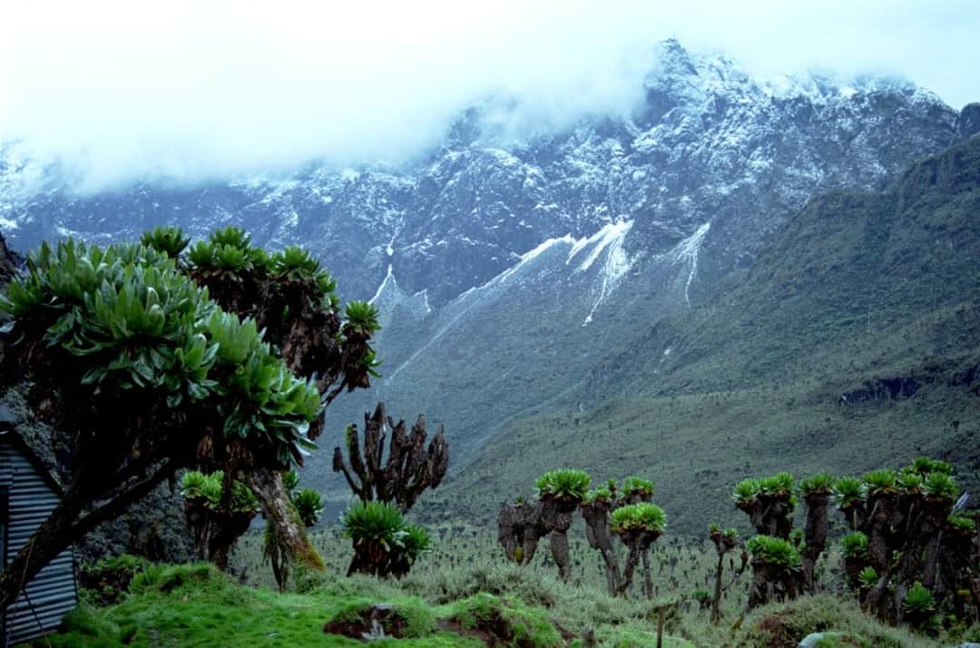
What you come for, more than the summit, is the vegetation. Above the heather the Rwenzori turns into something no photograph quite prepares you for: giant lobelia standing like green candles, tree groundsels four and five metres high with dead skirts of old leaves, everlastings in pink and white across the moraines, and all of it growing out of black bog under permanent mist. It looks less like a mountain than like a set built for a film about another planet. If that is what you are after, and you already know what a long wet day on your feet costs you, the Rwenzori is the best week in East Africa. If you want dependable views, dry boots and company on the trail, book Kilimanjaro instead and do not feel bad about it.
Best time to visit
There is no dry season here, only degrees of wet, and that distinction is the single most useful thing to understand before choosing dates. Kilimanjaro has genuine dry months. The Rwenzori has months in which rain is likely most days and months in which it is likely most afternoons. Anybody quoting you a guaranteed dry window is guessing.
The two relatively drier windows are roughly late December to the middle of February, and June to the end of August, sometimes stretching into early September. These are the months most treks are scheduled and they are the right default. In practice a good day in these windows means a clear cold morning with the peaks out, cloud building from mid morning, and rain or sleet somewhere between the early afternoon and dusk. That daily rhythm is why every camp starts early. The mountain shows itself before breakfast and hides for the rest of the day, so the party that leaves at first light sees more than the party that leaves at eight.
March to May and September to November are the wet periods, and they are wet in a way that changes the trip rather than just dampening it. The bogs are at their worst, the river crossings run high, the high passes can be sleeting when they would otherwise be merely cold, and the slick rock on the steeper ground becomes a real hazard rather than an annoyance. Some people go anyway and are rewarded with an empty mountain and vegetation at its most absurd, but this is not the window for a first visit or for a summit attempt on a tight schedule.
For Margherita specifically the calculation is different again. What matters on summit day is the state of the glacier and the rock above it. In the drier windows the ice tends to be more consolidated and the exposed rock step is more often bare and climbable. After a wet spell that same step can be glazed in verglass or buried under soft fresh snow, which is when guides turn parties around. Two groups climbing three weeks apart in the same month can have completely different days. Build a spare day into the itinerary if you can, because a single bad morning at the top of the mountain is the most common reason people go home without the summit.
High season
June to August and mid December to early February are the busiest, and Christmas and New Year is the one period when the huts genuinely fill. Even then, busy is a relative word on this mountain: you can walk a full day and meet nobody outside your own crew. The pinch point is Elena Hut on the Central Circuit, which is small, cold and the only realistic base for a Margherita attempt from that side, so summit parties need to be booked well ahead in July, August and over the festive weeks. The camps on the Kilembe route are larger and better spaced and rarely feel crowded at any time of year.
The Rwenzori is a vegetation mountain first and an animal mountain a distant second, and the vegetation is the reason to come. You pass through five distinct zones in three days. Montane forest at the bottom, dense and dripping, full of buttressed trees and fern. Then a bamboo belt that is dark and steep and slippery. Then the heather and Hagenia zone, where tree heathers grow to six or eight metres and every branch is furred with old man's beard lichen, so the light goes green and the whole thing feels like walking through a flooded attic. Above that the Afro alpine zone, where the giant lobelias and the tree groundsels stand about in the mist, and finally moraine, rock and ice.
The animals are there but they are hard won. Black and white colobus and blue monkeys move through the lower forest, chimpanzees live in the range and are heard far more often than they are seen, and the endemic Rwenzori red duiker and the little Rwenzori three horned chameleon are both genuine possibilities for anybody walking with their eyes open. Rock hyrax colonise the higher rocks. Elephant and leopard exist in the park and are effectively never encountered by trekkers. Nobody should book this mountain for its mammals.
Birds are a different matter, and serious birders treat the lower Rwenzori as a destination in its own right because the range holds a concentration of Albertine Rift endemics found in very few other places. The Rwenzori turaco is the one everyone wants, a crimson winged flash through the canopy, and the forest and heather zones also hold Rwenzori batis, handsome francolin, the Rwenzori double collared sunbird and a range of other sunbirds working the lobelia flowers well above 3,500 metres. Even trekkers who arrived indifferent to birds tend to be watching sunbirds on the giant lobelias by day four, because at that altitude there is very little else moving.
One detail worth knowing: the guides and porters are Bakonzo, the people of these foothills, and the mountain is not neutral ground for them. It carries meaning, it has names for its weather and its places, and the crew's relationship with it is not a performance staged for visitors. Ask about it on the walk rather than at the trailhead. It is the best conversation of the week and it will change how the range looks to you.
The Central Circuit, the original route
The Central Circuit starts and finishes at Nyakalengija near Ibanda, about half an hour from Kasese, and is run by Rwenzori Mountaineering Services, a Bakonzo community outfit that has held the concession for decades. Seven days is standard: up through forest to Nyabitaba, then a long day to John Matte, through the Bigo bogs to Bujuku under the wall of Mount Stanley, over one high pass to the Kitandara lakes, over a second high pass and down past Guy Yeoman to the forest. It is the shortest way to Margherita and it takes in the most dramatic single stretch of the range, the amphitheatre of Bujuku with Stanley, Speke and Baker standing around it. The costs are real. Height comes on fast, so acclimatisation is thin, the huts are old, cramped and permanently damp, and the boggiest ground in the Rwenzori is on this route. Choose it if the summit is the point and the schedule is tight, or if you want the historic line.
The Kilembe route, the Southern Circuit
The Kilembe route starts from the old mining town of Kilembe just outside Kasese and climbs the Nyamwamba valley. It opened relatively recently, it is operated by Rwenzori Trekking Services, and for most people it is the better choice. It takes more days to reach the same height, which is exactly the point, so the acclimatisation profile is far kinder. It spends more time on ridges and less time in bog, so the walking is drier and the views come more often. It passes a string of high lakes, Kopello and the Bugata lakes among them, that the Central Circuit never sees. The camps are newer, built with bunk rooms and drying space and a stove, which matters more than it sounds when everything you own is wet. It also carries fewer parties. Eight to nine days gets you to Margherita, and shorter versions stop at the high camps.
Margherita Peak on Mount Stanley
Margherita at 5,109 metres is the true summit of the range and it is not a trek. Summit day starts at one or two in the morning from Elena Hut on the Central Circuit or Margherita Camp on the Kilembe side, and runs twelve to sixteen hours. You scramble steep rock in the dark to reach the Stanley Plateau, rope up and put on crampons to cross the glacier, and then face the section that decides most attempts: a steep rock step, exposed by the retreating ice, usually climbed on a fixed rope and frequently glazed with verglass or plastered in soft new snow. Guides carry and fix the technical kit and they are competent, but you should already be comfortable walking in crampons, moving on a rope and being cold and exposed for hours. This is a mountaineering objective attached to a trek, and the honest failure rate is far higher than Kilimanjaro's. Weather, not fitness, turns most parties back.
Weismann's Peak and the Bugata high camps
This is the answer for the large group of people who want the Rwenzori's landscape without the glacier. From Bugata Camp on the Kilembe route, Weismann's Peak at around 4,600 metres is a walk with some scrambling and no ropes, no crampons and no glacier travel, and from the top on a clear morning you look straight across at the Stanley and Baker ice. Getting there and back takes five or six days from Kasese, which is a realistic slice of holiday rather than a full expedition, and you still cross the heather zone, the lobelia country and the high lakes. Most people who come home from the Rwenzori talking about the vegetation and the lakes and the emptiness saw all of it below 4,700 metres. If Margherita is not the reason you are coming, this is the trek to book and you will not feel you cut a corner.
Mount Speke, Mount Baker and the secondary summits
The range has six massifs and the big two are not the only objectives. Edward Peak on Mount Baker and Vittorio Emanuele on Mount Speke both rise above 4,800 metres and both are reached from the Bujuku area on the Central Circuit. Baker is generally the more approachable of the pair, a long steep scramble on rock that a fit trekker with a good head for exposure can manage, and it makes an excellent extra day for a party that has an acclimatisation day to spend or has been turned back from Margherita by conditions. Speke is harder and its condition varies with the season and the ice. Both are worth asking about because they add a summit day with real scale for very little extra logistics, and neither carries the glacier commitment of Stanley. Discuss them with your guide on the mountain rather than fixing them in the itinerary from home, since conditions decide.
The bogs: Bigo, Bujuku and the upper valleys
The bog stages deserve their own line because they are what people remember and what nobody warns them about properly. Between John Matte and Bujuku on the Central Circuit you cross Lower and Upper Bigo, an expanse of peat and tussock grass where the technique is to step from one grass hummock to the next, and where missing means going in to the knee or the thigh. Boardwalk has been laid across parts of it, which helps and does not solve it. Progress is slow, it is tiring in a way that flat ground has no right to be, and it soaks everything below the waist within an hour. Two pieces of practical advice from people who work here: wear gaiters over proper boots, and consider buying cheap gumboots in Kasese as many porters do, carrying your boots for the drier upper ground. Waterproof boots do not stay waterproof in a bog.
Short treks: two to four days into the forest and heather
You do not have to commit to a summit to get the point of this mountain. Short itineraries on both sides climb into the heather zone and back out in two to four days, reaching Nyabitaba and Lake Mahoma on the central side, or the Sine and Mutinda camps and the Mutinda lookout on the Kilembe side, where at around 3,700 metres you are already standing among the lichen draped heather with the high peaks visible on a good morning. This is the best value walking in the range for anyone short on time, unsure about altitude, travelling with less experienced companions, or slotting the Rwenzori into a wider Uganda trip that already includes gorillas and chimpanzees. It also serves as an honest trial run: three days will tell you very clearly whether you want the nine day version.
The full traverse, up one circuit and down the other
The most satisfying way to see the whole range is to climb one circuit and descend the other, entering at Kilembe in the south and crossing high into the Bujuku and Kitandara country before dropping out at Nyakalengija, or the reverse. It runs nine or ten days, it uses the gentler southern approach for acclimatisation and then delivers you into the most dramatic scenery on the mountain already adapted to the height, and it means you never repeat a valley. It also lets you fold in a Margherita attempt or a secondary summit with a spare day in hand, which is the single best insurance against the weather. It costs more days and more money than either circuit alone and it needs an operator who can coordinate porters and hut bookings across both sides, so ask that question specifically when you compare quotes.
Mountain
Rwenzori Mountains
Take it with you
Everything on this page in one document you can keep, print, or send to whoever you are travelling with. No email required.
Yes, in every way except one. Kilimanjaro is higher and altitude is the harder problem there. The Rwenzori is harder underfoot, harder in weather, harder on gear and considerably harder at the top. The daily terrain involves steep muddy climbs, tussock bog, wet root, slick rock and river crossings, and a stage that looks like eight kilometres on a map can take eight hours. You will be wet most days and you will not fully dry out for the duration. And Margherita itself, unlike Uhuru, requires crampons, a rope and a short technical rock step. A reasonable rule of thumb: if you found Kilimanjaro comfortably within your ability and wanted something harder, emptier and stranger, this is the mountain. If Kilimanjaro was at the limit of what you enjoyed, come here for a short trek rather than a summit.
You need more than trekking experience. Guides carry and fix the technical equipment and they will rope you across the Stanley glacier and up the final step, so you do not need to lead anything or place your own protection. What you do need is to be genuinely comfortable walking in crampons on ice at a slope, moving while roped to other people, and handling exposure on steep rock in the dark and the cold after several hours of effort. Someone who has done a guided alpine peak, a Scottish winter route or an equivalent glacier day will be fine. Someone whose entire mountain history is walking uphill will find the summit day frightening rather than enjoyable, and being frightened at 5,000 metres is how parties get slow and get turned around. If in doubt, book the trek to the high camps and treat Margherita as a separate future trip.
Bad enough that it defines the trip. On the bog sections you are stepping from tussock to tussock over black peat, and when you misjudge one you go in to the knee, sometimes to the thigh. It is slow, it is tiring in a way that flat ground has no business being, and it soaks everything from the waist down within the first hour. Waterproof boots become wet boots on day one and stay that way. The two things that actually help are decent gaiters and a pair of cheap gumboots bought in Kasese for the bog stages, with your proper boots carried for the drier and steeper upper ground, which is what most porters do. Bring more socks than you think is reasonable, keep one pair sealed in a dry bag for sleeping only, and accept that nothing dries in a hut at 4,000 metres in a cloud forest.
For most people, the Kilembe route. It takes more days to reach the same altitude, which gives a far better acclimatisation profile, it spends more time on ridges and less in bog, it passes a string of high lakes the Central Circuit never sees, and its camps are newer, drier and better organised. The Central Circuit is the historic line and it delivers the single most dramatic setting on the mountain, the Bujuku basin ringed by Stanley, Speke and Baker, and it is the shortest route to Margherita, which is exactly why people on tight schedules take it and exactly why its acclimatisation is thin. If you have nine days and want the best week, take Kilembe. If you have seven and the summit is the whole point, take the Central Circuit and accept the harder ascent profile. If you have ten, traverse both.
Roughly late December to mid February, and June to the end of August with some spill into early September. Those are the relatively drier windows and nearly all scheduled departures sit inside them. Understand what relatively drier means here: it means rain most afternoons rather than rain most of the day. The Rwenzori generates its own weather off the Congo basin and there is no month in which you can plan on staying dry. March to May and September to November are properly wet, with the bogs at their worst and the high passes prone to sleet, and while an empty mountain in those months has its own appeal, it is not the window for a first visit or a summit attempt. Whatever month you choose, start early every day, because the peaks are usually visible before eight and gone by eleven.
Yes, and they sit within a few dozen kilometres of the line. Ice survives on Mount Stanley and Mount Speke, and it is the last of what used to cover much more of this range. The retreat is not a projection here, it is something the older guides describe from their own working lives, and several of the range's smaller massifs have lost their ice entirely within the modern record. Nobody can put a reliable date on the end of it, but the direction is not in dispute and the practical effect is already visible: as the glacier snout on Stanley has pulled back it has uncovered steep rock that used to be under snow, which is why the final section to Margherita is now a technical step rather than the straightforward snow slope earlier expeditions described. The summit has become harder as the ice has gone.
Fitter than for Kilimanjaro, and the fitness that matters is endurance on rough ground rather than raw uphill speed. Expect six to nine hours of walking a day for most of the trip, on ground that gives nothing back, carrying a daypack while porters take the rest. Training on wet hillsides, in boots, with a pack, is worth more than any amount of gym work. On days, a summit attempt on the Kilembe route runs eight to nine days on the mountain, the Central Circuit seven, a traverse nine or ten, and the high camp treks four to six. Add travel: Kasese is the best part of a day's drive from Kampala or Entebbe, so a Margherita trip is realistically a twelve day commitment door to door, and more if you are pairing it with gorillas or Queen Elizabeth.
Waterproofing and redundancy. A genuinely good rain shell and rain trousers, not a showerproof jacket, because you will wear them for hours daily. Gaiters. Gumboots for the bog stages, buyable in Kasese, with proper boots carried for the upper ground. Far more socks than you would take elsewhere, and one pair kept dry in a sealed bag purely for sleeping. Dry bags for everything inside your kit bag, since porter loads get rained on regardless of what they are wrapped in. A warm sleeping bag, because the huts are damp and cold and damp cold feels worse than dry cold at the same temperature. For a summit attempt you will also need or hire boots stiff enough to take crampons, plus gloves you can actually climb in. Ask your operator precisely which technical items they supply and which they expect you to bring, and get it in writing before you fly.
Absolutely, and this is the most useful thing on the page for many readers. The summit is a mountaineering objective that a minority of visitors are equipped for, but nothing that makes the Rwenzori special is at the top. The lichen hung heather forests, the giant lobelia and groundsel, the high lakes, the moraine country and the total absence of other people are all found between roughly 3,000 and 4,700 metres, and all of it is reachable on a walking trek with no rope, no crampons and no glacier. Weismann's Peak from Bugata Camp gives you a genuine high summit and a clear view of the ice with none of the technical commitment. People who book the short version and enjoy it come home happier than people who book Margherita, get turned round by weather at 4,900 metres, and spend the flight home feeling they failed at something.